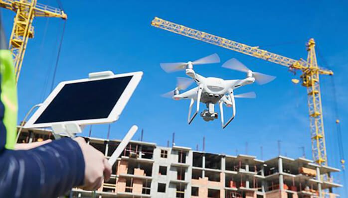
Amidst all technological advancements and equipment application in the construction process, People are still mesmerized when they encounter a hovering device. Apart from all social media glamour, hype of drone delivery, FPV trends, Drones or Unmanned Aerial Vehicles (UAVs) have been put to work for the benefit of business operations. New implications in construction have begun to uplift the standard benchmark for operations and certainly making it much more efficient and sustainable.
This article will deal with direct and indirect aspects of Construction concerning to the Drone Technology.
What are the Direct Benefits of Drones in Architecture, Building and Construction
1. Obtaining Fast and reliable Data
On-demand, Fast Iterations of the visual data are available. These equipments can provide precise visual data of any site much faster than any physical inspection. Not just fast, Project managers can have real-time aerial inspection of ongoing works and equipment and asset managing.
2. Gets accurate and Comprehensive Data
Aerial data through drones is coordinated with GPS points. These include an accurate survey of distances, elevations, volumes, and surfacing. This data is used to create Digital models of the real-time site conditions for better functioning.
3. Reduces Work time and Thus Cost
Physical inspection has an associated labor cost to it. Data collected through drones saves time through fast monitoring and reduces cost at possible stages of construction.
4. better Accountability and Record Management
When the process of documenting is achieved that fast and frequent, records are maintained stage-wise. Tracing the fault or key points during construction are retrievable through rigorous records.
5. Skips Remote Accessability
Managers and supervisors can access the remote site areas without physical inspection or having to rely on workers for progress reporting.
6. Reduced Risk and Increased Safety
Visual Imagery reduces the workers’ exposure to places that are hard to reach or prone to machinery accidentals. Construction sites are accessible to qualified personnel only, Drones can also be used to identify any breach to prevent any potential mishappening.
Where Drones Can Be Applied in Building Construction
1. Pre Planning Phase
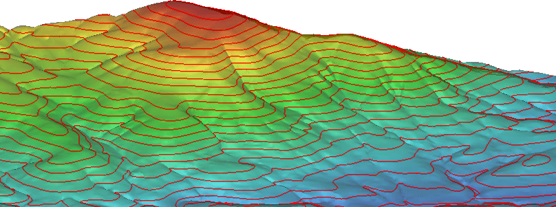
Even before the bidding of any construction projects, Topographical surveys are initiated for potential site parameters. These factors are extracted from the visual data by UAVs. The Digitial Terrain Models can show gradients, elevation nudges, and other factors that can be used to strategize built-up blocks, material storage, excavation works. This data is useful in assessing the cost at a preliminary stage.
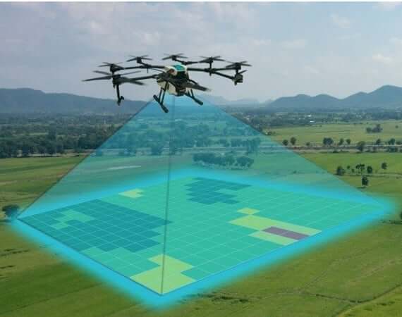
2. Create Digital Terrain Models
3D Modelling Softwares and modellers can Create Digital Terrain Models through orthographic mapping of Drone Data. These DTMs can serve all stated benefits and also measuring the stockpiles of various materials on a construction site.
3. Design and Planning Phase
Architects can refer to the visuals from the site and overlay design proposals in real-time instances. This helps assess the practical and aesthetical visions. 3D models allow us to analyze and incorporate details in working through existing conditions.
4. Customer Accountability
Large scale projects have multiple stakeholders who are eager to track the progress of the investment. Relatively low expense of data collection can be effective for regular reporting to clients and managers.
![]()
5. Execution
Monitoring the Phases of execution helps in abiding by the work timeline.
Earthwork Markings and cross-checking can be generated through geospatial coordinate systems and color codings.
This coordinate analysis helps in generating volumetric data for cut/fill analysis.
6. Abiding the Safety Norms
Safety on a construction site is a major concern. Aerial surveys by drones limit the physical interventions in accident-prone areas while inspecting. They can also be used to identify any security breach or material and equipment monitoring.
7. Monitoring Potential Delays and Progress Tracking
Planning through visual reports, Maps, and tracking created through DTM is sent to managers who can use them to monitor progress. The progress tracking reports are used to avoid delays that can cause overbudgeting.
Stages that can be monitored are excavation, Erection sequences, Machinery Locations, Material Monitoring, Worker Inspection, and Structure Finishes.
8. Handover of Project
Detailed Documentations are to be presented upon the handover of any project. These reports are maintained through a rigorous timely approach. Specifically, the client can go through the documentation once before taking the handover.
It can be stated that investing an amount on UAVs (Drones) can save a lot of cost on other factors. Drones can be much more than producing High definition Imagery. Building Information Modelling collaborations through drone technology are yielding effective results. Upgraded equipments like the infrared, geo-sensors and thermal scanners can be added on the drones for significant products. As a conclusion, It is clear that Creative Approach and Competitive Strategy are urging the use of drones in A.E.C.
– Anshul Kulshrestha